Residential
Creates a residential development for the sub-area selected via the generation of new parcels and buildings. Existing buildings and lots are removed. New parcels are created within city blocks, which are the largest portions of residential land separated by the local street network. City blocks are generated by oriented bounding box (OBB) subdivision, described by Vanegas et al. (2012) and centered around the concept of repeatedly dividing land along the midsection line of a bounding box, until the subdivided regions reached a certain size limit.
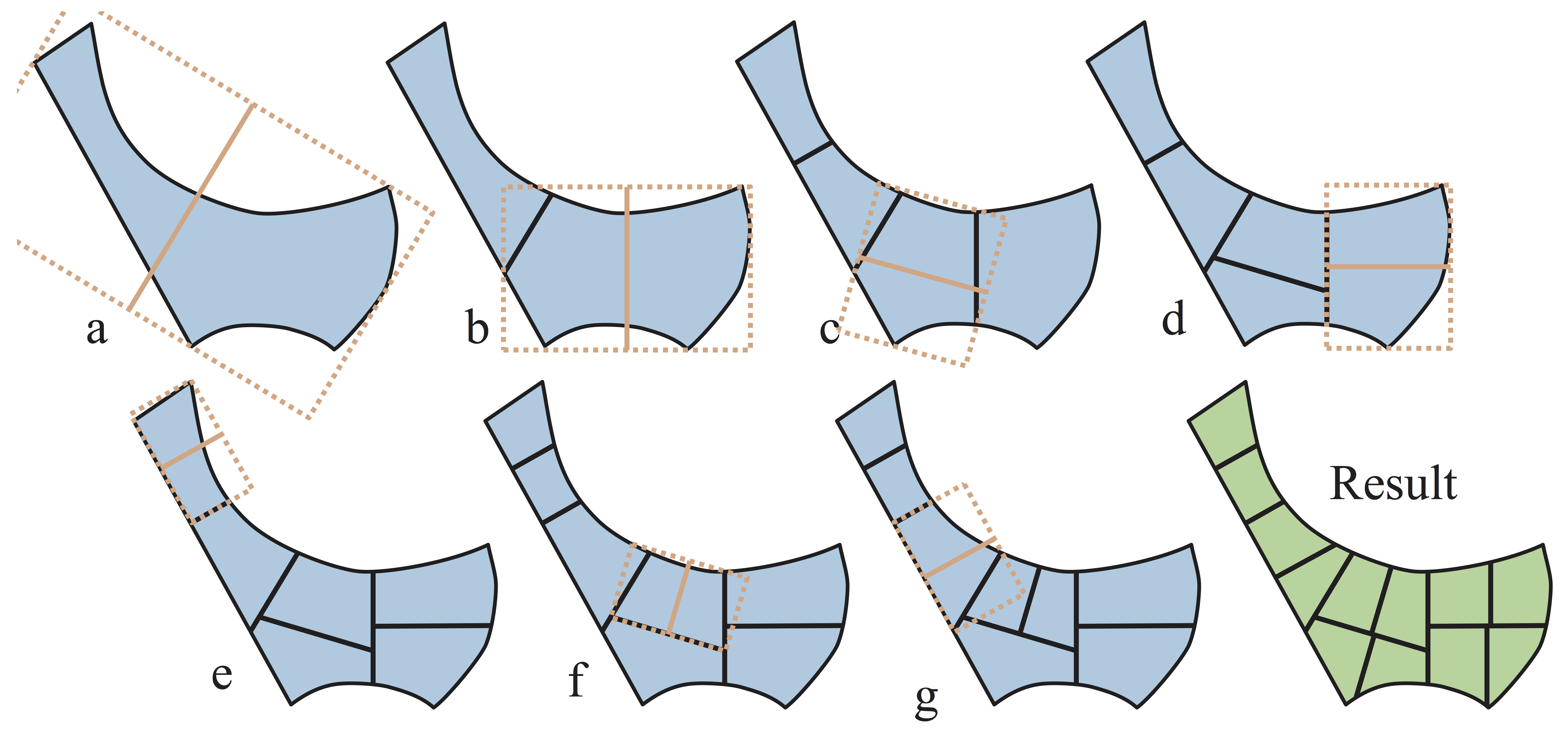
Fig. 10 Figure 1. OBB subdivision example
Once the city blocks have been created, an internal offset is applied to them – the difference between the offset and the original city block becomes the model’s representation of the local streets, and the offset is divided into habitable lots based on the parcel dimension parameters. Dwellings are then created at the centroid of suitable parcels (i.e. where the area is more than 280sqm or the building footprint would be less than 80% of the total area), and demographic data is downscaled onto the households. Finally, trees are generated along the perimeter of the city block offset. Their spacing is dictated by the relevant tree spacing parameter, and the tree canopies are 11m in diameter (this value will be editable in a future release). The land cover grid is then updated to reflect all of the changes in urban form.
Parameter
Name |
Type |
Description |
Default |
Values |
|---|---|---|---|---|
City block width |
DOUBLE |
The width of the bounding box at which initial subdivision of the residential land stop occurring (i.e. if a bounding box is formed with a width equal or less than this, the respective residential region around which it is formed is not further subdivided) |
76 |
0.1 - |
City block depth |
DOUBLE |
The depth of the bounding box at which initial subdivision of the residential land stop occurring (i.e. if a bounding box is formed with a depth equal or less than this, the respective residential region around which it is formed is not further subdivided) |
200 |
0.1 - |
Street offset |
DOUBLE |
The measure of the offset applied to the original city block created from the residential sub-area and the oriented bounding box subdivision |
7.5 |
0.1 - |
City parcel width |
DOUBLE |
The width (where width is the dimension parallel to the street-facing dimension) of the parcels created from the offset of the city block |
15 |
0.1 - |
City parcel depth |
DOUBLE |
The minimum depth (where depth is the dimension perpendicular to the street-facing dimension) of the parcels created from the offset of the city block (i.e. a row of lots will not be created if it causes another row of lots within the same city block to sustain a depth less than the parcel depth value) |
35 |
0.1 - |
Site cover |
DOUBLE |
The fraction of parcel covered by the building |
0.6 |
0 - 1 |
Building height |
DOUBLE |
The height of the buildings generated on the parcels |
6 |
0.1 - |
Residential units |
INTEGER |
The standard residential unit for the sub-area that has been developed (i.e. if set to 1, each new building developed will be assigned demographic data equal to one average household; if set to 2, each building will be assigned data equal to two average households) |
1 |
1 - |
Hardstand fraction |
DOUBLE |
The fraction of the area of a parcel that is taken up by hardstand surfaces |
0.5 |
0.0 - 1.0 |
Garden fraction |
DOUBLE |
The fraction of the area of a parcel that is occupied by irrigated grass |
0.4 |
0.0 - 1.0 |
Street Tree spacing |
DOUBLE |
The space between the trees generated along the perimeter of the city block offset |
22 |
0.1 - |
% of lots with Tree |
DOUBLE |
Percentages of lots that install a tree |
100 |
0 - 100 |
number of trees per lot |
INTEGER |
Number of trees installed on a lot |
1 |
0 - 4 |
Advanced Parameters
Name |
Type |
Description |
Default |
Values |
|---|---|---|---|---|
Building width |
DOUBLE |
The width of the buildings generated on the parcels (width is the dimension parallel to the street-facing dimension of the parcel) |
10 |
0.1 - |
Building length |
DOUBLE |
The length of the buildings generated on the parcels (length is the dimension perpendicular to the street-facing dimension of the parcel) |
14 |
0.1 - |